Estimated reading time 18 minutes, 59 seconds.
How could a modern passenger jet just disappear? That’s the question that dominated aviation in early 2014 with the strange loss of Malaysian Airlines Flight MH370. Almost five years earlier, the same question was being asked about the disappearance of Air France AF447.
In both instances, the aircraft were relatively new and well-equipped. MH370 was a Boeing 777-2H6ER (registration 9M-MRO; leaving Kuala Lumpur, Malaysia, for Beijing, China), which first flew in May 2002. AF447 was an Airbus A330-203 (registration F-GZCP; heading from Rio de Janeiro, Brazil, to Paris, France), which first took to the air in February 2005.
Both planes had aircraft communications addressing and reporting systems (ACARS), which transmitted on-board diagnostic data to their respective corporate headquarters via satellite. Both flights were tracked in real-time over land using air traffic control radar—and both planes were apparently lost over water, out of this radar’s range.
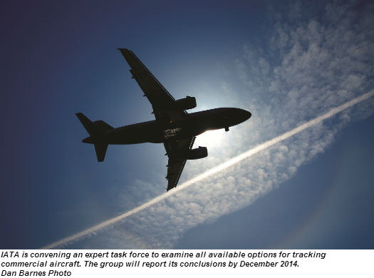
“In a world where our every move seems to be tracked, there is disbelief both that an aircraft could simply disappear and that the ‘black box’ is so difficult to recover,” said Tony Tyler, director general and CEO of the International Air Transport Association (IATA). Speaking on April 1, 2014, at the IATA OPS conference in Kuala Lumpur, Tyler then declared, “Air France 447 brought similar issues to light a few years ago and some progress was made. That must be accelerated. We cannot let another aircraft simply disappear.”
He pledged that, “IATA will convene an expert task force that will include ICAO participation to ensure that the work is well coordinated. This group will examine all of the options available for tracking commercial aircraft against the parameters of implementation, investment, time, and complexity to achieve the desired coverage. This group will report its conclusions by December 2014, reflecting the need for urgent action and careful analysis.”
“Flight following” will be central to the work of the IATA task force. It refers to reporting and monitoring an aircraft’s physical location, speed, heading, and altitude in real-time; using GPS tracking onboard the aircraft and satellite transmissions between it and the ground. Had MH370 and AF447 been successfully tracked and monitored in this manner, their airlines would have been alerted to trouble while the planes were likely still aloft. At the very least, the recovery process would have been far easier to execute, because their final locations would have been known.
Skies attempted to contact Canada’s major commercial airlines to find out what flight following equipment they are using; however, all declined to be interviewed for this article. Typically, however, these fleets are tracked using air traffic control radar, plus data provided by their onboard ACARS systems.
Canada is a world leader in the area of flight following, with a number of companies providing various levels of service. One of them, FLYHT Aerospace Solutions, has received media attention from Bloomberg, Forbes, and The New York Times during the MH370 search, due to FLYHT’s cutting-edge AFIRS 228 (Automated Flight Information Reporting System) product. But three other companies—Latitude Technologies Corporation, SkyPlan Services, and SkyTrac Systems—also offer flight following systems and services that enhance pilot and passenger safety.
FLYHT AEROSPACE SOLUTIONS
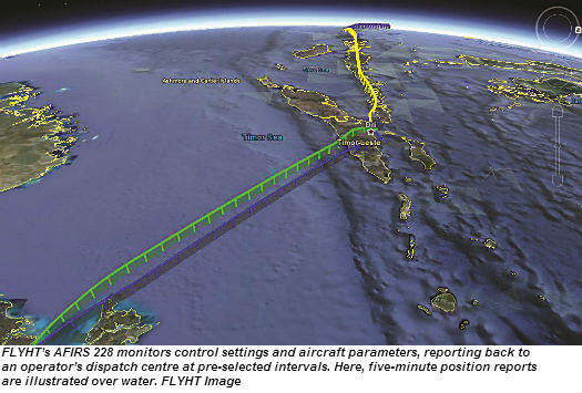
Based in Calgary, FLYHT Aerospace Solutions makes the AFIRS 228 flight following system. Built into a 12.55 x 2.27 x 7.66-inch chassis that is housed in an aircraft’s avionics bay, the AFIRS 228 connects to the flight data recorder (FDR) signal buses.
Using this connection, the AFIRS can monitor aircraft systems, engine performance and all other data being provided by the aircraft’s sensors to the FDR. It also captures data from navigation and communication buses, and discrete signals such as door and landing gear switches. Collectively, this provides the AFIRS with all the informa-tion needed to accurately monitor all control settings and aircraft parameters, for every phase of flight. The actual parameters measured, and the time intervals at which they are measured, are customer-configurable.
The AFIRS-collected data is then transmitted by the unit’s built-in Iridium satellite modem. Once in the Iridium system, the AFIRS data goes to FLYHT’s Calgary and Cloud servers. The company’s UpTime ground service system stores and then forwards this information to the customer via the Internet in real-time. It can be viewed in flight following mode via the UpTime web-based dashboard using Google Earth, or on any aircraft situational display such as the Sabre Flight Explorer. Weather and flight information such as fuel on board, ETA or other data can be overlaid on the route map, to give the dispatcher a better real-time view of the flight’s progress.
Worth noting: The AFIRS 228 can support SatCom voice and data communications for phone calls, as well as the upload/download of mission-specific data such as weather, passenger requirements and terminal gate allocations. If there is a medical emergency onboard, the AFIRS 228 can link into the MedAire Medlink Global Response Centre. Another plus: Included on the AFIRS 228’s cockpit control is an event button. With one push, the crew can alert their dispatch centre without making a satellite phone call. Such instances could include a diversion for weather, a system abnormality, or any other situation that does not warrant a voice call.

“In emergency situations, our FLYHTSTREAM software solution—which runs on the AFIRS 228—will automatically stream data back to the ground, providing position, altitude, attitude airspeed pitch, roll, yaw, airframe indicators and avionic system modes,” explained Matt Bradley, president of FLYHT. “This information is received by the operator within 15 seconds of the onset of the emergency, and continues until the situation returns to normal or the aircraft crashes. In the case of AF447, their dispatch would have known there was a problem hours before the aircraft was deemed overdue.”
FLYHT’s AFIRS 228 equipment is currently flying on 400 aircraft operated by 40 customers worldwide, with contracts also signed with L-3 Communications for installations on Airbus aircraft and NetJets Europe. Most notably, FLYHT has cracked the potentially huge Chinese civil aviation market, where all commercial transport aircraft will be required to have onboard satellite communications by the end of 2017.
“Critics claim that this kind of GPS-based real-time flight following is expensive and bandwidth-hungry—but it isn’t,” Bradley told Skies magazine. “First, the AFIRS 228 equipment is inexpensive compared to other aircraft avionics components; not to mention the multi-million dollar price tag of a modern commercial passenger aircraft. Second, you do not have to send out the complete rundown of aircraft systems continuously in real-time. Automated, triggered streaming enables FLYHTSTREAM to be automatically activated to send data only in an emergency, a capability that is unique in the industry. For normal operations, bursts of data outlining position, heading, airspeed, and altitude every three or so minutes are enough, and the amount of bandwidth required is well within Iridium’s narrow limits.”
LATITUDE TECHNOLOGIES
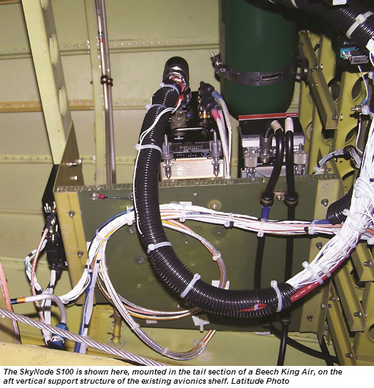
Located in Victoria, B.C., Latitude Technologies designs and sells automated flight following (AFF), flight data monitoring (FDM), SatCom, messaging avionics and services. They are known for their S100 and S200 SkyNode voice/data transceivers. Both are small, rugged, multifunction units that support a wide range of communications functions, including real-time flight following. They can interconnect with a range of avionics devices and sensors, capturing and relaying real-time performance data via the Iridium and Inmarsat satellite constellations.
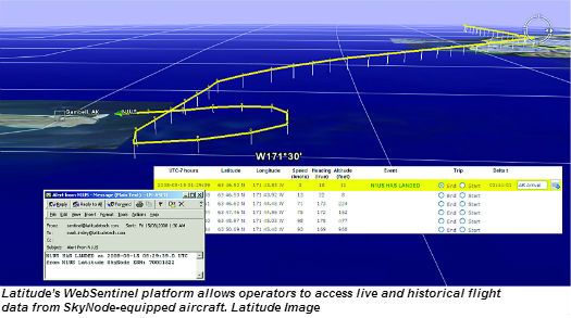
For aircraft operators, Latitude Technologies makes all of this data highly intelligible and web-accessible via its Latitude WebSentinel online subscription platform. “With WebSentinel, you can view both live and historical flight data from your SkyNode-equipped aircraft, using popular mapping software,” said Latitude Technologies president Mark Insley. “In real-time, you can see where your aircraft is, and keep an eye on parameters such as speed, altitude, heading, and whatever performance indicators you select.” The WebSentinel platform can also be set to send email alerts whenever takeoffs and landings occur.
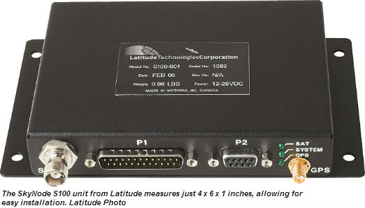
The small size of the S100 (4 x 6 x 1 inches) and S200 (3 x 4 x 11 inches) SkyNode transceivers, the ease of avionics bay installations, and the Internet-accessibility of the WebSentinel platform have won many aviation customers for Latitude Technologies, including the U.S. Department of Justice, B.C.’s Conair Aviation, and Ontario’s Ornge air ambulances.
“Our flight following solutions are also used by Air Creebec, Air Inuit, and North Cariboo Air,” said Insley. “We have made a number of international sales as well, including to Malaysia Airline’s wholly-owned regional carrier, MASwings. They recently ordered six new DHC-6 Series 400 Twin Otters from Viking Air; all of which are being equipped with our S200 SkyNodes, FDM, and flight following services.” Unlike Malaysia Airline’s main commercial service, MASwings flies to smaller regional centres in East Malaysia (on the same island as Indonesia) using ATR 72-500s and new ATR 72-600s, plus a mix of older DHC6-300s and the new DHC6-400s.
Latitude Technologies’ success in selling its flight following services worldwide points to their affordability: “Per air mile covered, it costs a fraction of a penny,” Insley said. “This is why the arguments put forward by some critics that flight following is too expensive for commercial airlines is simply nonsense. It is not only extremely affordable, but the fact that our service is being used by small regional carriers with far smaller resources than the major carriers also proves how valuable real-time flight following is.”
SKYPLAN SERVICES
Unlike other flight following providers, SkyPlan Services of Calgary does not sell aircraft equipment. Instead, the company works with its aviation customers’ dispatchers to identify the sources they currently use for flight following—air traffic control, ACARS, and data/voice communications with aircraft—and then helps them format this data for use with SkyPlan’s Aurora operations board workstation.
“Aurora allows an airline to set up a fully-integrated flight managements system, including flight following and weather watch capability,” said Craig Mariacci, SkyPlan’s VP of sales. “The system can also be used to request and receive web-delivered tabular weather and NOTAMs.”
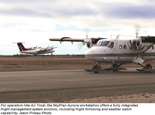
In the specific area of flight following, Aurora can monitor all flight position reports, plus departure/arrival/enroute weather. “You can keep your crews and operations department alerted about weather and airport issues in real-time, and arrange diversions quickly and transparently,” said Mariacci. “SkyPlan is a very cost-effective way to create an effective flight following system, using your existing resources and ways of doing business.”
SkyPlan currently provides dispatch services for Enerjet and Regional 1 from Calgary (with some Regional 1 flights operating in Afghanistan), Trans Capital Air from Toronto (also with United Nations flights operating in various locations), Air North in Whitehorse, and Air Tindi in Yellowknife.
“We provide dispatch services, so we are acting as the listed airlines’ dispatchers,” said Mariacci. “Every customer may have their own flight following software that we are trained to use.”
SKYTRAC SYSTEMS
Based in Kelowna, B.C., SkyTrac Systems provides a full range of flight following services. These are based upon the company’s ISAT-200A transceiver and external aircraft satellite antenna, which connect into a cockpit-mounted display terminal and QWERTY keyboard interface. The ISAT-200A transceiver chassis measures 5.24 x 3.90 x 13.30 inches. It mounts in an aircraft’s avionics bay, where it interfaces with the plane’s sensors and avionics outputs.
“The ISAT-200A combines flight following, satellite communication, data recording and aircraft systems monitoring into a single system,” said Stephen Sorocky, chairman and CEO of SkyTrac Systems. “Using the aircraft’s own GPS receiver, it can be configured to send out regular positional/ situational reports to ground stations, and can display this information on web-accessible maps.”
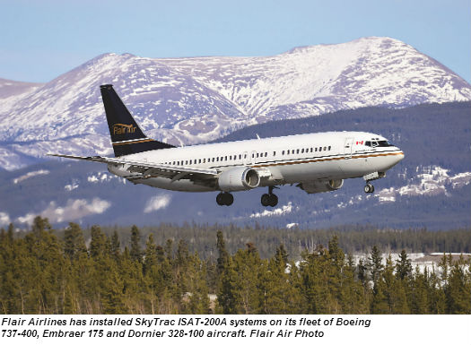
Flair Airlines has installed ISAT-200A systems on its fleet of Boeing 737-400, Embraer 175 and Dornier 328-100 aircraft. “Every three minutes, our aircraft transmit a report showing their position, speed, altitude and heading to a password-protected website,” said Bill Hardy, Flair Airlines’ VP of operations. “We take this data and overlay it on Google Maps, allowing us to know exactly where our aircraft are at all times.”
As for the price? “I estimate that it cost us under $30,000 per aircraft to install and configure the ISAT-200A transceivers and antenna,” replied Hardy. “Based on the efficiencies it has generated by improving our fleet and resource management, I’d say it paid for itself in six months.”
Sloan Helicopters is another SkyTrac customer. “Serving the oil-and-gas and forestry sectors, we operate in remote locations where communication is difficult and emergency services are not close at hand,” said Kim Rossi, operators manager and chief pilot with Sloan. “With SkyTrac’s system, we are always in contact with our helicopters and crew and are aware of their locations.”
SkyTrac’s equipment has proven successful in a wide variety of aviation applications, including aerial firefighting, oil-and-gas, forestry and aircraft charter. Logic suggests it could work for major commercial carriers, too.
FLIGHT FOLLOWING: NOW AND IN THE FUTURE
The variety of flight following solutions offered by these four Canadian companies proves that this technology is not only ready for deployment now, but available in a range of offerings that can work for all kinds of budgets—including those of commercial carriers.
Meanwhile, game-changing technology looms on the horizon, and it is called Aireon. Spearheaded by Nav Canada, ENAV (Italy), the Irish Aviation Authority and Iridium Satellite LLC, Aireon will extend the flight following capabilities of automatic dependent surveillance-broadcast (ADS-B) technology from its current land base to the entire globe.
Designed to improve upon radar-based aircraft tracking, ADS-B is a “next gen” onboard aircraft technology that provides air traffic control with real-time information about each aircraft’s identity, position, altitude and speed. Currently, reception of this ADS-B data is limited to ground-based stations. However, by equipping the next generation of 81 Iridium low earth orbit satellites with ADS-B transceivers, ADS-B communications will be possible with aircraft wherever they may be, especially if they are flying over remote oceanic areas that are not covered by traditional radar.
“Aireon will allow us to improve flight tracking substantially, providing for safe closer spacing and more use of optimal altitudes on major air routes,” said Michelle Bishop, Nav Canada’s director of government and public affairs. “We estimate that airlines flying over the North Atlantic will save $125 million in fuel through more efficient flight paths, in the first year alone.” Bishop expects that the ADS-B equipped satellites—known as Iridium NEXT—will be ready to begin service in early 2018. The first is due to be launched in 2015, with 66 required to provide full planet coverage.
In the meantime, IATA is preparing to dig into the flight following issue in earnest. “We are at the very beginning of an eight-month process through which we intend to arrive at a consensus decision on the best way to ensure that we never have another situation where an aircraft simply disappears, and we have no idea where it is,” said Mona Aubin, manager of IATA Corporate Communications, Canada. “All options are on the table.”